A 45-million tonne avalanche rumbles down Yukon’s Mt Steele
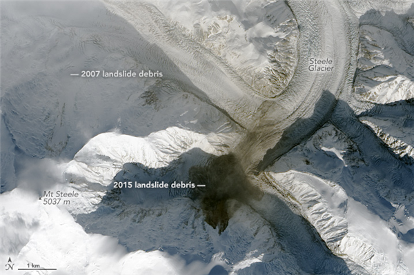
Image from NASA Earth Observatory. Go to Nasa to view before and after photos.
A huge avalanche in Canada’s Saint Elias Range set off seismic waves on Oct. 11, 2015 after Mt. Steele let go of 45 to 50 million tonnes of ice and rock from just below its peak.
There were no reports of injuries. The location is remote.
The exact location of the avalanche was not known until satellite confirmation. Landsat 8 images taken Oct. 6 and Oct. 13 show a large brown swath on the sides of Mt. Steele where the rock slid. Scientists Colin Stark and Göran Ekström from Columbia University detected the event, which otherwise might have gone unnoticed, on a global earthquake monitoring network.
American Geophysical Union reported the size of the run.
“The crown of the landslide is at an elevation of about 3350 m, the total vertical distance is about 2200 m to the toe, with a run out over the Steele Glacier of about 3700 m.”
Mt. Steele is known for an even bigger avalanche in 2007. According to the Yukon Government, the mountain dropped a huge amount of ice and rock that traveled up to 5.76 km with a maximum vertical descent of 2164 m, leaving a deposit 3.66 km2 in area on Steele Glacier. The 2007 landslide was detected on seismometers around the world, as it shook the earth with a force equivalent to a magnitude 5.2 earthquake.
Mount Steele is the fifth highest mountain in Canada and the eleventh highest peak in North America reaching the height of 5,073 metres.
Image from Mt. Steele from a plane from Ben and Jenn. Hat tip Lee Lau
More News

{{ commodity.name }}
{{ post.title }}
{{ post.date }}
Comments