How Auracle’s Pipe Stalker™ Revolutionizes Global Kimberlite Detection
Auracle Geospatial Science announces its Pipe Stalker™, an advanced exploration tool that discretely and anonymously searches for the signal combinations that indicate probable kimberlite-pipe type occurrences under water and in heavy overburden environments. The Pipe Stalker™ is a breakthrough technological tool that decreases time and cost during the exploration phase and increases rate of discovery in a sustainable way.
The Pipe Stalker™ technology can be applied year-round, over large, inaccessible and extremely challenging environments.
Diamonds remain a scarce resource despite world diamond production that has tripled since 1980. In the last 25 years, fewer than 1% of the more than 12,000 kimberlite deposits found worldwide contained enough diamonds to make them economically viable.
The majority of mined diamonds are recovered from kimberlites. As known deposits are mined and eventually exhausted, the search for high-value deposits will require diamond operators to work in increasingly challenging environments, with a focus on low-risk, cost-effective solutions that have less impact on the environment.
The Pipe Stalker™ is a breakthrough tool that enables sustainable, cost-effect detection of new kimberlite occurrences in complex scenarios: extreme weather conditions, deep deposits, challenging environments, underwater and remote locations.
Mapping and Modeling Subsurface Geology
Auracle’s pioneering investigation of the subsurface began with the application of satellite hyperspectral and Synthetic Aperture Radar (SAR) data to discern geological structures, features and units. By combining proprietary acquisition and processing algorithms, Auracle developed a robust automated tool for identifying and monitoring subsurface geological structures, features and units. The 3D Mapped Underworld Dimension (MUD™) Model works at, near and underneath the earth’s surface to “see through” water, deep vegetation, ice, snow, rocks and soil to identify structures and lithologies. This technology makes it possible to explore and map, from space, with millimeter-level accuracy, day or night, through all weather, and in remote or inaccessible areas.
“I am very impressed by the Auracle technology and its potential application to the vast tracts of the planet that are covered by sand, glacial till or vegetation” said Richard Williams, P. Geo and CEO of Cornish Metals Inc.
“The ability to see through the cover and identify exploration targets quickly and cost effectively will be of great benefit to the exploration effort to discover new mineral deposits,” said Williams.
The Unfolding Story of Pipe Stalker™ Development
Next, Auracle applied its MUD™ model in the search for signature features and variables unique to kimberlite deposits. Through studying known kimberlite occurrences on Somerset and Baffin Islands and integrating the advancements of the MUD™ system, Auracle identified the environments, structure and subsurface features unique to kimberlite pipes.
In late 2021, Auracle used 10 known kimberlite occurrences on the Nunavut Mainland as a test site to prove the effectiveness of the Pipe Stalker™ tool to disclose subsurface kimberlite occurrences that were not apparent at the surface. “We were excited to identify some of the variables and features associated with kimberlite occurrences in such an extreme environment,” said David McLelland, CEO and Chief Scientist at Auracle Geospatial Science. “But we wanted to expand the subsurface search parameters and to visualize these in 3D,” McLelland added.
The following images are visual evidence of the viability of Pipe Stalker™ in the search for new kimberlite-pipe type occurrences.
Image 1: This is the location of the occurrence in a high-resolution color satellite image. The area is covered with overburden and contains numerous water bodies. There are no apparent signs of the blind pipe occurrences which in some parts are under water.
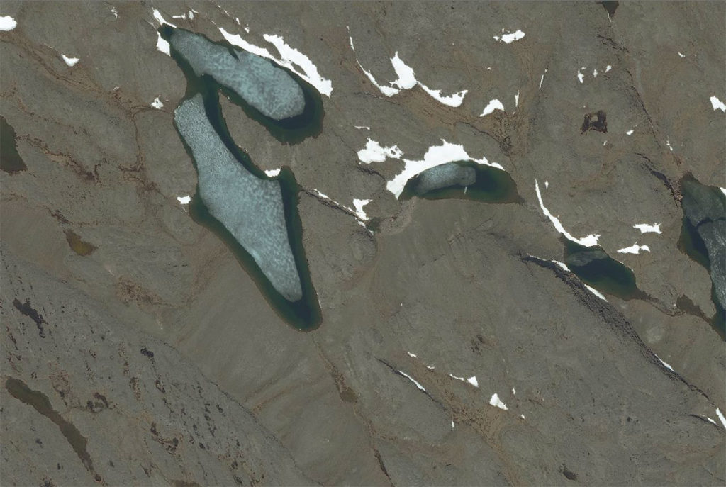
Image 2: This is a plan view of the Pipe Stalker™ radar cloud. The very dark outline represents a texture-density derivative.
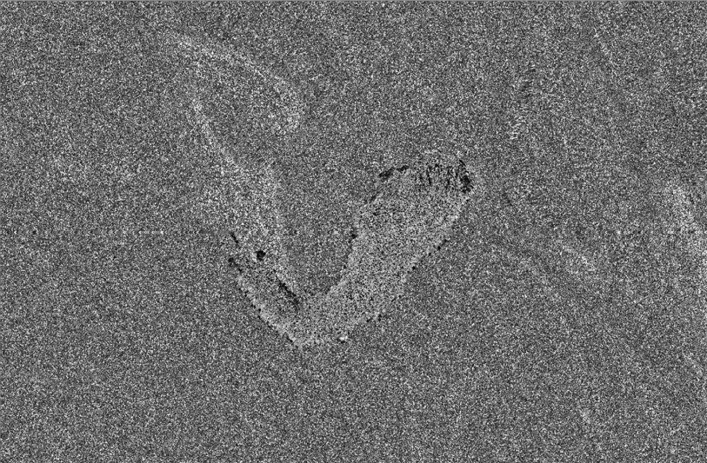
Image 3: This is the same plan view with the published mapped outline of the established kimberlite occurrence in green. The mapped outline very strongly spatially correlates to the very dark texture derivative outline.
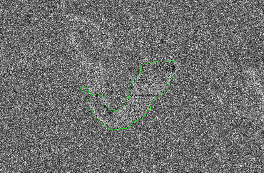
Image 4: The yellow shading defines a zone of fractured material detected by Pipe Stalker™ and texture differential surrounding the mapped kimberlite pipe occurrence.
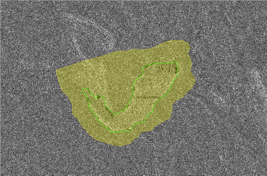
“The contrast in physical properties between the mapped kimberlite pipe and the surrounding country rocks detected by and delineated in the Pipe Stalker™ could not be clearer” observed Paul Metcalfe, Ph.D. P.Geo. FGS, a geologist with more than 40 years’ experience in volcanology, igneous petrology and mineral exploration.
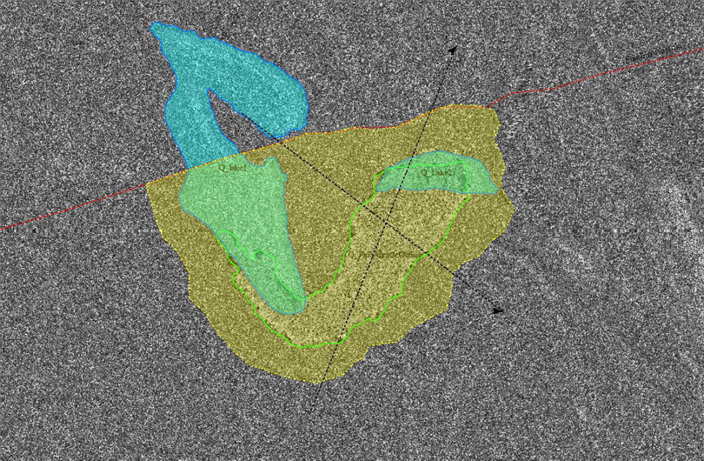
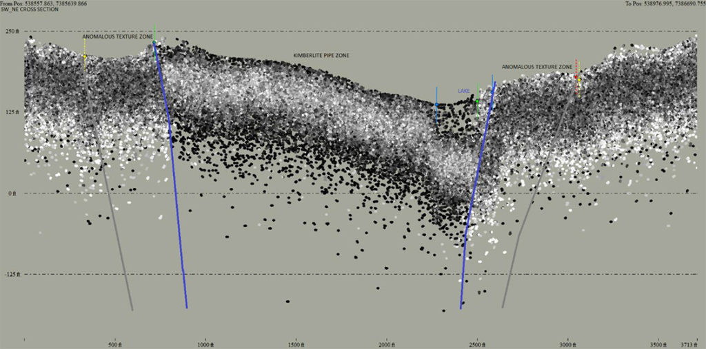
Image 5: An East-West red linear feature forms an apparent northern boundary to the yellow fracture zone.
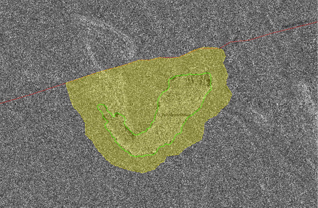
Image 6: Water bodies (in transparent blue) are overlain on the model to show the areas of water penetration by Pipe Stalker™. Note by using Pipe Stalker™ water presence is not a concern in identifying subsurface and underwater structures.
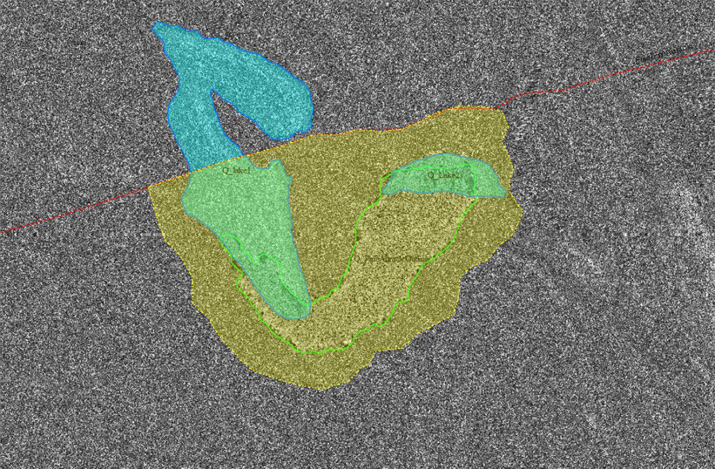
Image 7: A cross-section delineation from NW to SE intersects the model to provide locational information for 3D volume slices which are shown in the next images.
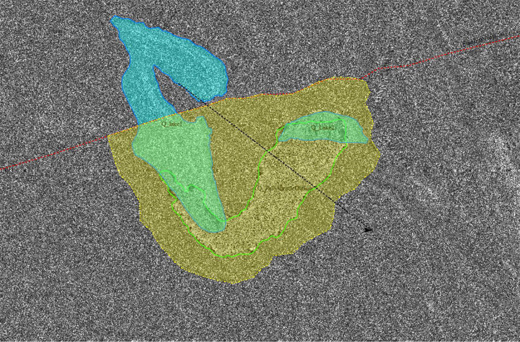
Image 8: A second SW to NE section line is delineated showing another 3D volume slice orientation.
Point Clouds
In traditional surveys, volumes of data points are in the range of a few thousand to 100 thousand. 3D Point Clouds, products of the Pipe Stalker™, display volumes of a million to 10s of millions of data points. These automated Point Clouds represent competent reflectors at and under the earth’s surface which can be analyzed for their variability. These images and sections make clear the differentiation achieved in the plan view and section views of the 3D radar point cloud that show the 4 variables:
- Difference in densities
- Difference in textures
- Differences in resistivities
- Structural bounds
“They are like subsurface LiDAR and can be viewed in the same way as LiDAR, using standard common XYZ or LAZ format software,” explained McLelland.
Image 9: NW-SE section tomographic or 3D volume slice through the point cloud model.
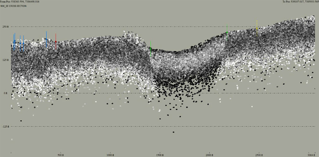
Image 9a: The structural and density margins of the pipe below grade.

Image 9b: The structural and textural margins of the fracture zone surrounding the kimberlite pipe.
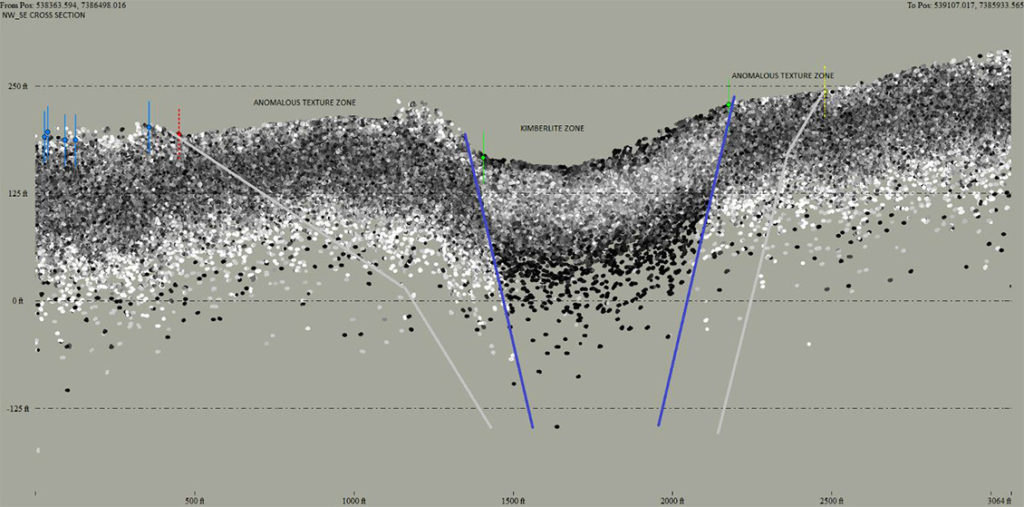
“The peripheral shatter (or fracture) zone common to ultraplinian eruption vents is also clearly distinguishable by its physical properties. In addition, the termination of linear features in the surrounding country rocks clearly delineates its outer boundary,” according to Dr. Metcalfe.
Image 10: SW to NE section tomographic or 3D volume slice through the point cloud model.
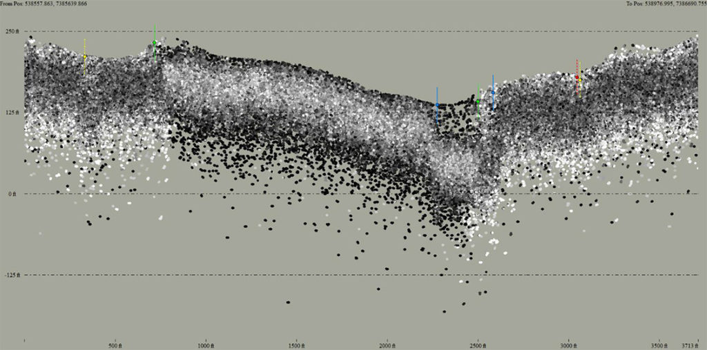
Image 10a: The structural and density margins of the pipe below grade.
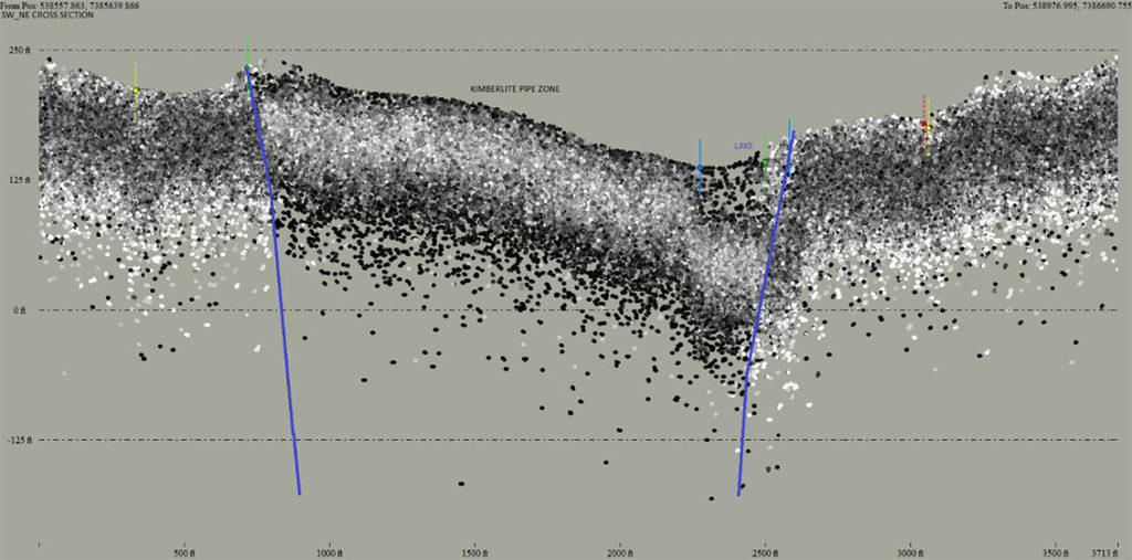
Image 10b: The structural and textural margins of the fracture zone surrounding the kimberlite pipe. The extent of the pipe is still seen under the lake in the image which is significant proof of the underwater capabilities.
Dr. Metcalfe adds, “Furthermore, moderately to steeply dipping discontinuities within the shatter zone, unremarked in this study, are consistent with fractures commonly developed on a variety of scales in post-eruption conditions of decompression and subsidence.”
Refining Geophysics to Determine Drilling Locations
The Pipe Stalker model provides a well-defined 3D view of target zones. This ability reduces time and cost in locating kimberlite pipes and focuses drilling efforts. With significant drilling expenses, especially for deep holes, this level of prediction and accuracy informs decision-makers and requires fewer drill holes when testing prospective targets. In addition, because Pipe Stalker eliminates “boots on the ground”, the added benefits to the environment and safety benefits to the operators yields a win-win condition.
Because the technology penetrates ground cover, overburden and water to reveal underlying rock surfaces, structures, and texture, Pipe Stalker™ can be fused with and enhances 3D seismic and other geophysical inversions. With exposure of the non-outcropping near surface, Auracle corrects and improves geological maps and models with structural features including non-apparent strike and dip that deepen and refine targets, without being on the ground, including remote and inaccessible areas. Field work can be planned and targeted, saving valuable time and money.
Embracing Disruptive Tools to Reduce Environmental Impact
While there are some ground-breaking practices in the diamond industry today, more can be done across the industry to address the ESG priority. Some companies and governments still spend enormous amounts of money and time exploring for new targets with outdated or unreliable technologies, missing opportunities to embed end-to-end sustainable practises across the supply chain.

Auracle continues to pioneer tools and initiatives that champion ESG standards. Pipe Stalker™, an advanced exploration tool enables responsible and ethical detection of kimberlite occurrences for the sustainable management of these rare natural resources. Because Pipe Stalker™ is conducted remotely, it creates no unnecessary human footprint, requires no social license, and does not cause cultural interference.
Contact Us Today
For more information on Auracle1s exploration products and services and to learn more about how we can help you optimize your kimberlite-pipe discoveries, visit www.auracleremotesensing.com or call 250-738-0459.
More News
{{ commodity.name }}
{{ post.title }}
{{ post.date }}


4 Comments
manuel julio francisco
Meus melhores cumprimentos para os senhores.
sou prospector mineiro ,neste momentos estou a implementar um novo projecto com 3 400 km2,egostaria saber mais sobre a eficacia das vossas ferramentas
Manuel Julio Francisco
Jody Polk
Manuel
Please contact me at [email protected] and we can discuss your project and needs.
Saludos!
JC Wessels
I am from Northern Cape in South Africa..on my farm could be a really large kimberlite pipe..is there away of hiring an operator to make a survey..
nagella kishore
Excellent